


SityTrail - Plage et dune

Alfredy
User GUIDE
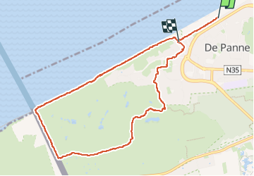

Length
9 km

Max alt
15 m

Uphill gradient
61 m
Km-Effort
9.8 km

Min alt
0 m

Downhill gradient
67 m
Boucle
No
Creation date :
2024-10-08 10:08:47.577
Updated on :
2024-10-08 10:08:47.577

FREE GPS app for hiking
 SityTrail
IGN / Geographical institutes
SityTrail Plus
The world is yours!
About
Trail of 9 km to be discovered at Flanders, West Flanders, De Panne. This trail is proposed by Alfredy.
Positioning
Country:
Belgium
Region :
Flanders
Department/Province :
West Flanders
Municipality :
De Panne
Location:
De Panne
Start:(Dec)
Start:(UTM)
471301 ; 5661404 (31U) N.
Comments